Ojai, California is located in a mountain valley a little more than an hour northwest of LA. It is known as an artist's colony, but did you know it also has some of the best mountain running in California? Although it can get hot in the summer, the Ojai valley, has moderate temperatures for most of the year. With an average high temperature of 69 degrees during the two coldest months of the year and very little rain, it is a great place to go trail running in the winter. This article describes only a few of the many trails in the Ojai area.
Most of the trials in the Ojai area are in the Los Padres National Forest. At this time, the Los Padres National Forest has instituted an "experimental" fee for hikers. Once these kinds of fees are in place it is hard to get rid of them (all institutions, especially governments, always need more money so they can grow themselves), but, in this case, there is some talk about not renewing it. The fee is, of course, not required of hikers and runners, but it is required if you plan to park your car anywhere within the boundaries of the Los Padres National Forest. An annual pass costs thirty dollars (also good for the Angeles National Forest, the Cleveland National Forest, and San Bernardino National Forest) or you can buy a one day pass for five dollars. But here is the good news: to run the National Forest trails nearest to Ojai, you can park outside the boundaries of the National Forest and run in.
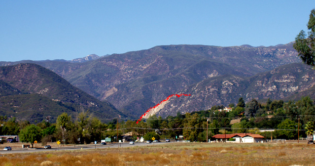
You can get to Ojai by going north on state route 33 out of Ventura, or on highway 150 that comes up from Santa Paula. As you approach Ojai, you will see a large mountain range to the north. That is the Los Padres National Forest. Let's start in the center of the town of Ojai and work our way deeper into the National Forest. The central north-south street in Ojai is Signal street. It runs right through the middle of the small, quaint downtown district. If you go north on Signal street for about a mile, you will see a "National Forest trails" sign pointing to the left down a dirt road. Follow that dirt road to the end. There is a parking area and more signs pointing the way to the Pratt-Foothill trail. This is a narrow rocky trail that will give you a chance to work on your nimbleness and visual acuity. Of course, you can always walk this part (until it opens up). It is dusty in the summer and can be wet in the winter after a rain. The trail wanders past a few outlying homes and crosses the paved Foothill Road until it eventually enters the National Forest and turns into a dirt road (mountain bikes are allowed). Here is a photo taken from the town with the general path of the trail marked in red.
As you can see from the photo, this trail is up up and more up. But it is not as steep as it looks. It meanders upward for a couple of miles where it intersects with another dirt road (marked in blue) that heads off to the east (to the right). That trail eventually intersects with Shelf road, another great running location. The Shelf road trail goes east along the shelf of the lower part of the mountain and it keeps on going for a LONG ways past orange and avocado groves. Great views of the city up there. Both of these trails will be sunny for long stretches, so wear your sunscreen.
The Pratt trail continues on up, gradually heading off to the west to connect with the Cozy Dell trail. There is a saddle at the intersection with the Cozy Dell trail (there is a sign) with a single-track trail that continues on upward. If you are ready for a REALLY good run, you can go on up there all the way to Nordoff Peak, one of the highest peaks in this mountain range. It is another four miles of sidehill, switchback running/climbing from the saddle intersection. A great run for serious trail runners (carry lots of water - four more miles of steep uphill takes longer than you think).
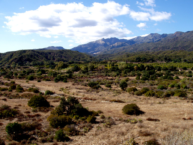
If you want to run up to that saddle intersection via the Cozy Dell trail, start right next to the road that leads into the National Forest. Drive north out of Ojai on highway 33 for about two or three miles. You'll see a large parking area on the left side of the road. The trail starts right across the road from the north end of the parking area. The Cozy Dell trail is even steeper than the Pratt-Foothill trail. It is also rocky in places. This trail is shaded in the morning and sunny in the afternoon. Below is a picture showing the canyon and the general path of the Cozy Dell trail.
As for the trails deeper within the Los Padres National Forest, there are so many up there it is beyond the scope of this short article. The only highway going into the National Forest is that same highway 33 that leads past the Cozy Dell trailhead. About four or five miles up that highway, on the right, you will see a National Forest service building. You can buy passes there and get a free map of all the hiking-running trails in the National Forest. They also sell more detailed maps there.
There are also less well developed trails within the Los Padres National Forest farther to the west of Ojai, across the Ventura river basin. Below is a photo of that area.
by TrailRunningUSA staff
Know of a good running trail? Want to write an article for TrailRunningUSA? Click Here to tell us about it.

 Back to the TrailrunningUSA